


Landslide and flood early warning system based on IoT and WSN technology
Landslide and flood early warning system is an integrated solution of advanced technology based on the Industrial Revolution 4.0 platform, including IoT on-site sensors automatically monitor and record parameters that cause landslides and flash floods such as: slope displacement, hydrological and physical properties in soil, as well as precipitation using various tools. Measuring machines: rain gauge; extensometer, inclinometer, rotameter, total station, laser scanner and acoustic emission sensor (AE) and GPS to observe slope displacement and deformation. Time-do- main reflectometer (TDRs), strain gauges and barometers for measuring changes in the hydrological and physical properties of soil.
.
Sensors, alarms and on-site data processing nodes that communicate over a low-energy wide area network (LPWAN) are the main components of the system for early warning landslides and flash floods. This network allows very low energy devices to transmit radio information at very long distances, the ground point to point can reach tens of kilometers, and if a balloon is used as a relay station, the information can be transmitted as far as hundreds of kilometers.
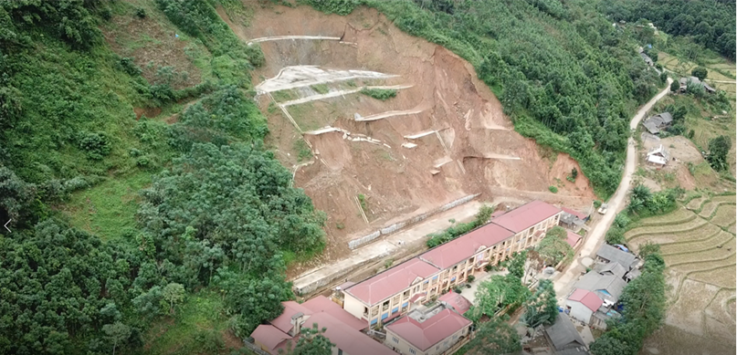
In residential areas located in an accident-prone area, incident sensors are installed that automatically send out warning signals when they are buried or collapsed. This system sends a signal to emergency rescue units that occur immediately after an accident so that the response time is fastest, and the loss of life is minimized.
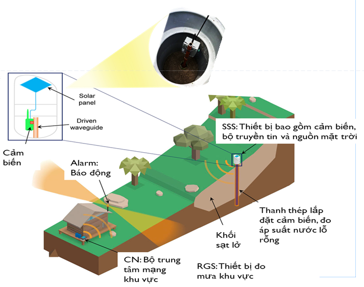
OPERATION PRINCIPLES OF MONITORING AND ALARM SYSTEM FOR SLOPE LANDSLIDES
Equipment for measuring slope displacement (SMS): including AE sensor, satellite positioning device with 2.5cm accuracy, pore water pressure sensor; LPWAN transmitters (low power wide area network), renewable power source. On-site data processing node: collect data from measuring equipment, signal threshold processing, alarm trigger and transmission of information to the Internet. Alarm equipment (ALARM) in residential areas: sirens, lights in each residential area, radio receiver. Central operating system record information from networks of sensors, apply numerical and AI prediction model to evaluated data history, gives early warnings on areas requiring special monitoring (incorporates rain forecast data), wide area network information via Internet, text message, telephone, Direct information on site status with disaster forecasting, disaster prevention, rescue local agencies, installation just plug in without drilling), operate commissioning (auto threshold detection, remote monitoring center connection), ultra-low power consumption from solar cells.
OPERATION PRINCIPLES OF MONITORING AND ALARM SYS TEM FOR MUD FLOODS
Mud flood measuring equipment installed on stream bed (AES): AE sensor, water level sensor; flow speed and volume sensors; LPWAN transmitters, renewable power sources. The slope displacement meter (SMS) is installed on a slope where there is a possibility of a landslide. On-site sensors are designed to be installed without drilling. Energy-saving ultra infrared image Al analyzer. On-site data processing node and rain gauge. Artificial intelligence and cloud-based real time analysis with fast notifications. Residential alarm device (ALARM). Central operating system sends public notifications about possibilities of landslide, flush via text messages, phone, live information of field status with disaster forecasting, disaster prevention, rescue, local agencies.
OPERATION PRINCIPLES OF MONITORING AND ALARM SYSTEM FOR SPILLWAY FLOODS
Flood measuring equipment (AES) is installed upriver. Alarm device (ALARM) at the spillway underground (+ on-site data processing node + rain gauge). Installation (in the small rock pool upstream), operation (automatic threshold detection, remote monitoring center connection), ultra-low power consumption from solar cells. Using low energy wide area network (LPWAN) technology, connecting information systems with integrated disaster rescue and prevention. This is the research result of the state-level project VT-CN.04/17-20 that has been accepted "Research on technology access using balloons dropped in the stratosphere with integrated technology of information transceiver station for monitoring, navigation, search and rescue and measurement of atmospheric physical environmental parameters”.
.
For more detailed information about the solution, please contact us for the best advice!
Software - Automation - Control Joint Stock Company (CadPro)
Address: No. 11 Chau Long - Ba Dinh - Hanoi
Hotline: (84) 969.733.568
Email: This email address is being protected from spambots. You need JavaScript enabled to view it.
Website: http://cadpro.vn